
Your input on final plans is needed

Many iterations of planning have taken place, and the latest plan can be found on the County's website. Your input on this plan is crucially important at this time, as the plans near completion.
The expectation is that this project would be fully built next year.
Attend the coffee hour with the County the Bicycle Coalition is hosting, or one of the other open houses hosted by the county, and tell them how you feel about this intersection. More details on how to get involved at the bottom of this post.
Join us on January 27
Nearing final plans for Franklin/Cedar/Minnehaha
If you have ever traveled through the intersection of Franklin/Cedar/Minnehaha, you know how confusing, wide, fast, and unfriendly it feels. With the second most bicycle crashes, this is the second most dangerous intersection in Minneapolis. It’s also one of the most dangerous intersections in Hennepin County, with crash rates more than two and a half times the “critical rate.”
Over the past few decades, many groups have put many hours into planning a more bikeable, walkable, driveable Franklin, including the intersection of Minnehaha, Franklin, and Cedar. Specifically, Seward Neighborhood Group and Seward Redesign, have been working to make this intersection safer since 2000.
Hennepin County will be paving Franklin from 21st to 16th, and Cedar is being repaved down to 22nd. This is an opportunity to improve one of the most dangerous intersections in the City. The City and County have been working together to put together a design that improves the area within their budget, while also looking forward to expected developments.

Existing intersection of Franklin Ave, Cedar Ave, and Minnehaha Ave
Keep it simple- close Minnehaha
The fundamental change proposed to improve the intersection is to close Minnehaha north of Franklin, which would simplify and align traffic lanes. This plan includes removing the signal at Minnehaha, and making it so you can only turn right onto and off of Franklin from Minnehaha. To relieve some of the traffic in the intersection, wayfinding signage would be added to encourage cars to use 17th. In addition, layout changes on Franklin and Cedar will make car traffic much more efficient than in its current configuration, according to the County's traffic projections.
Another fundamental change to this intersection would be to improve medians to slow turning cars, provide pedestrian refuges, and to construct a median on Franklin to prevent left turns onto Franklin.
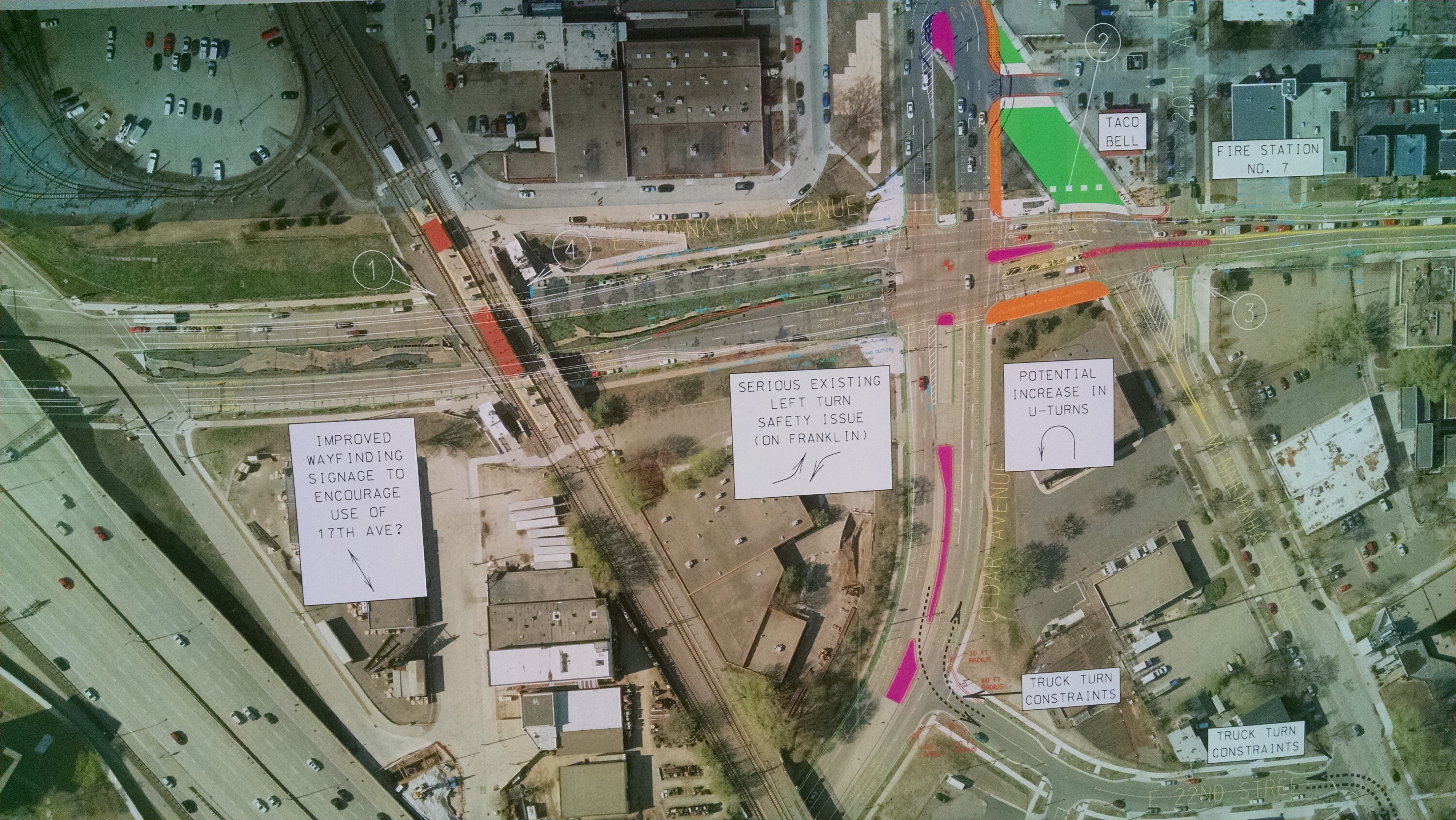
The green section of what is now Minnehaha north of Franklin indicates a space for pedestrians, and will no longer allow traffic through. Pink shows new medians.
What about bikes and pedestrians?
From Minnehaha, how do bikes turn left/westbound on Franklin, and how do bikes continue north?
From Minnehaha, the plan would be to encourage bikes to turn left across Minnehaha on the south side of Franklin. The area between Cedar and Minnehaha would become a "multi-use trail." From the multi-use trail you would need to cross Franklin with the signal.
To head westbound from Minnehaha
Continue on the westbound bike lane on Franklin
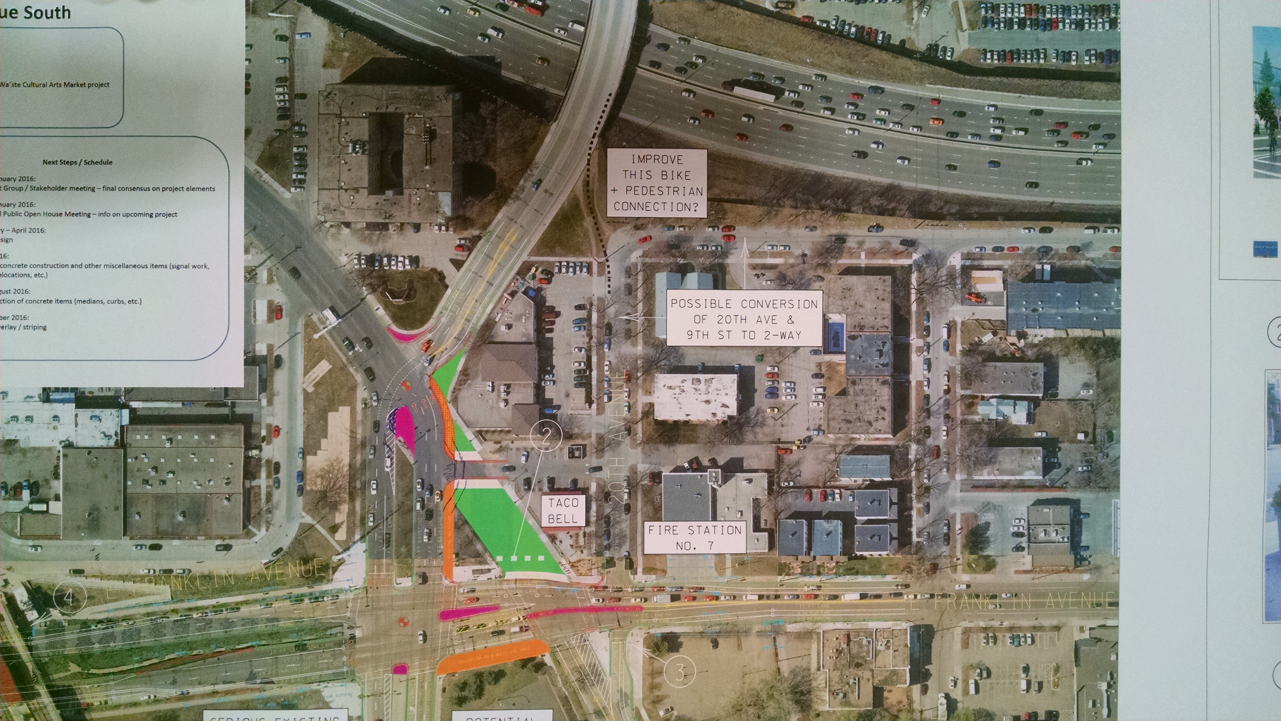
To head north onto 20th Ave S
Continue on the multi-use trail on the east side of Cedar, which connects to 20th Ave S.

Further west on Franklin, under the LRT, an improved pedestrian crosswalk near the Anpetu Was’te cultural arts marketplace will be installed.
After Minnehaha north of Franklin is closed, that area and part of the wide Taco Bell driveway area will be turned into public space. How this space will be managed is still being worked out. Making this area into non-driveable space tightens up lanes, slows down turns, and aligns traffic lanes- all contributing to simplicity and safety for bikes, peds, and cars.

These are examples of the elements that would close Minnehaha to car traffic, north of Franklin
Two options for Minnehaha Ave S alignment
There are two options being considered for the configuration of Minnehaha where it connects to eastbound Franklin.
1. One option is to take out the existing median, make the turning radius tighter (and therefore slower), and align Minnehaha to 20th Ave. This option seems to be the most bike and pedestrian friendly.

2. The second option is cheaper because it uses the existing median to separate northbound and southbound Minnehaha traffic, which has a wider turning radius which may encourage cars to gain speed as they turn.

Challenges remain
The County still needs to have further conversation with the firehouse and Taco Bell on Franklin. Conversations have been started, but there is still work to be done there.
A question remains about, how will bikes safely navigate crossing Minnehaha when heading westbound, like described above? Minnehaha will have low traffic volumes, but how are we making this crossing safe for everyone?
There is also a potentially dangerous situation involving a double-threat for pedestrians crossing from Minnehaha to 20th Ave, using the small, 4-foot median on Franklin as refuge. One westbound Franklin lane becomes two at that point, creating a dangerous “double-threat” situation for pedestrians. A possible answer is to this is to push the point where Franklin's one westbound lane becomes two further west, by only about four car lengths. This could mean a wider median for pedestrians to take refuge on, and would mean pedestrians only have to cross one lane of westbound car traffic, eliminating the double threat scenario and greatly improving pedestrian safety. The County is not planning a crosswalk here, but pedestrians will cross here and they deserve safety.
Making plans with room to grow in the future
There is a realization that this intersection project has the potential to better connect bikes and pedestrians, but that scope must be limited to fit budgeted time and money. The best this process can do, short of finding more money and making the connections now, is to make sure what is being built now does not limit future connections.
- A bike connection from the LRT trail to E 22nd St is in the works. This intersection project will not be able to create a connection to the LRT trail, but it will be designed to accommodate a future connection project.
- The City’s bikeway plan identifies 20th Ave S as a future protected bikeway, but without much more specification about where exactly it would be built- a one-way or two-way bikeway are both possibilities.
- Possible bike and pedestrian improvement on the “goat path” or “desire path” which pedestrians and sometimes bikes use to connect 20th Ave segments.
Crucial time for input
There is no better time to give your input on this plan. Please come to one of these events to talk with the County about your needs as a road and sidewalk user. The voices of opposition are always very loud, so supportive voices that like the overall plan (even if you have concerns!) are very important for this process!

www.bikewaysforeveryone.org/redesign_meetings


Showing 4 reactions